
By Julian Hunt
[Originally Published in Urban Land, August 2008]
“Some 700 tiny parcels of unusable public land in Washington, D.C., currently are under the administration of the National Park Service. These small urban parcels could be returned to the District of Columbia, which could convert a number of these parcels into small neighborhood parks.”
In the public mind, the National Park Service (NPS) is steward of the sublime, charged with preserving America’s landscapes. Behind the words of the legislation that created the NPS in 1916, the unspoken mission was to protect what little remained of the primordial forest. The etymological origins of the word “forest” might be traced from the Latin foris “outside”, perhaps, in the sense of a place outside or beyond human influence or administration. Nothing of the Earth now remains in its primordial state of wilderness outside human ownership or exploitation, except by degree. There is no place that has not been mapped, cataloged, photographed, and brought within a legal framework. What is “outside” has disappeared.
The real estate portfolio of the National Park System contains not only properties of the most iconic beauty and historic significance, but also a small and growing collection of curiously unclassifiable miscellany, the odd donation, and unwanted properties shunted into the back files of the NPS. This last classification includes properties held in public trust from well before the foundation of the National Park Service, with a particular concentration in the District of Columbia. Some of the oldest federal lands delineated by French architect Pierre L’Enfant’s plan back in 1791 for the layout of Washington ended up in the NPS portfolio in 1933 after a long succession of transfers.
Located beyond the National Mall, which stretches two miles from the U.S. Capitol to the Lincoln Memorial, these miscellaneous properties in the District of Columbia are particularly distinctive because of their urban setting and arrangement. Urban parks within the National Park Service portfolio do exist, most notably the 75,000-acre (30,352-ha) Golden Gate National Recreation Area in San Francisco and the Gateway National Recreation Area outside New York City, but they are still characterized and used largely as natural landscapes.
Excluding the National Mall; Rock Creek Park, the 12-mile-long (19-km) urban green area that bisects Washington; and a ring of old Civil War fortifications, the District portfolio is made up of a constellation of circles and squares that mark the junctions of important diagonal avenues of the L’Enfant Plan, inspired by the urban squares of Paris. In his role in the design of the District of Columbia, statesman/architect/naturalist Thomas Jefferson left some enigmatic notes that suggest he was doubtful of the utility of the diagonal avenues as he was of the competence of L’Enfant himself. The few extant sketches in Jefferson’s hand, snippets of an urban DNA for the design of the city of Washington, reveal a preference for orthagonality as Jefferson had previously shown in the Land Ordinance of 1785, which established the basis for the Public Land Survey System- the one-square-mile grid laid out over the continent.
The contradictions involved in implementing an urban plan based on the French Enlightenment and driven by concentrated royal power- in a land that was little more than an enormous wilderness- by a fledgling and decentralized federal government has bedeviled the urban history of the District of Columbia. The subsequent subdivision of the ten-squaremile federal district, after L’Enfant’s dismissal, was managed by three appointed federal commissioners who arbitrarily deviated from many aspects of the L’Enfant Plan. It could be argued that their careless misapplication of the plan resulted in the many tiny triangular fragments left over from the unresolved intersections of L’Enfant’s diagonal avenues with the orthogonal street grid. However, it has been rare to find a building with a well-resolved corner on any of these diagonal streets, suggesting a general lack of interest in the necessary design effort and funds to resolve these unusual geometries.
Triangle Park on Q Street NW and Connecticut Avenue NW
Whatever their origin, nearly 140 years later, hundreds of these tiny fragments of unusable public land fell under the administration of the National Park Service. Today, they constitute some 700 tiny parcels of little more than concrete traffic peninsulas and islands. Lady Bird Johnson, who initiated the 1965 Highway Beautification Act, may have had these eyesores in mind. For a period of time, some effort was made to maintain these sites. However that effort eventually seemed to wane and has been long forgotten, leaving the triangles to revert to their natural state of neglect and ruin.
While the administrative procedures for large parcels of parkland are defined by the 2006 NPS management policies in reasonable detail, a more specific policy for small urban parks is nonexistent. In a chapter devoted to neighborhood parks in her seminal book The Death and Life of Great American Cities, Jane Jacobs noted that parks by themselves do not make a neighborhood, but that the neighborhood makes the park. The NPS mission to preserve and protect was never intended to cover the administration of very small urban parcels, which require detailed knowledge, attention, and understanding of surrounding neighborhoods at a level that a large bureaucracy, such as the National Park Service, is unable to render.
The particular case of the fragmentary constellation of tiny parks in the District of Columbia is further clouded by the anomalous status of the District as the only jurisdiction in the United States without a vote in Congress, leaving the District in a peculiar state of exception with regard to its relationship with the federal government. Where the management of the urban parks of New York and San Francisco can be overseen by citizen activism and the constituent services of an elected local member of Congress bringing attention to a jurisdictional matter, the responsibility for the parks in the District is diffused and without the critical feedback mechanism of the vote. Historically, Congress as a body is responsible for the administration of the District, but constituent interests lie elsewhere. This diffusion of responsibility is obscured by a deployment of independent and uncoordinated federal oversight commissions, planning bodies, and preservation boards.
Dupont Circle, the most famous and popular of the L’Enfant circles, is populated with splintered benches, and isolated by a traffic plan that makes crossing to the park an exercise in jaywalking.
Thomas Circle marks the transition to downtown from the residential neighborhoods just to the north. A circle badly disfigured by traffic engineers in the 1960s, it was recently renovated to an unsubstantiated historic form that makes no acknowledgement of the vitality of the changing neighborhood. Fake historic aluminum picket fences; standard issue concrete walkways; a new archipelago of traffic islands that provide no aid, shelter, or thought of the pedestrian; an incoherent array of light poles to illuminate traffic; and a lonely equestrian statue of the Rock of Chickamauga.
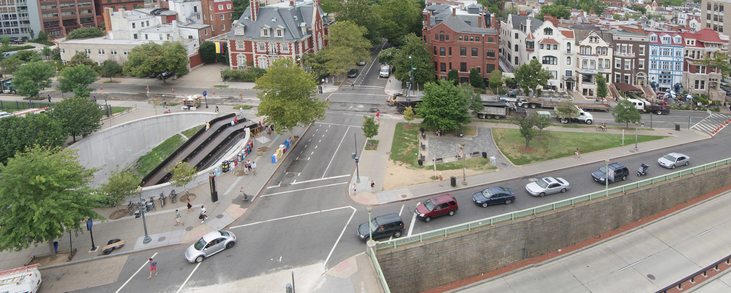
Reservation 149 (the smallest properties are designated by number; “reservation” refers to the old military designation that has since developed an entirely different meaning), a dilapidated triangular park near Dupont Circle was recently the object of neighborhood attention. A new sophisticated design, to be paid for by private money, that acknowledged the presence of both the popular spontaneity of the Dupont Circle Farmers’ Market and the iconic design of the Dupont Metro entrance, was summarily rejected by the NPS Special Assistant for Partnerships. The design was arbitrarily replaced by an insipid revival from records of a 1929 plan, a period when neither the Metro nor the farmers’ market existed, and the immediate urban environs were entirely different from those of today. This offers a stark contrast to a similar traffic island recently renovated in Manhattan at 14th Street and 9th Avenue.
There are legions more of small urban parcels that document a dysfunctional stewardship that has allowed an administrative state of exception to reign over the District of Columbia. Without political influence to defend its interests, the District of Columbia stands 51st in a line of 50 states for funding responsive to its needs. Who would want to administer some 700 triangular fragments of mostly useless real estate that now function as little more than traffic islands? These lands do not contain magnificent stands of Sequoias, virgin Hemlocks, glacial melt water, salmon runs, or any endangered species except a form of extremely rare habitat- open space in the nation’s capital- the connective tissue that supports public life.
Despite internal resistance from the National Park Service to transferring any kind of property from its stewardship, and specific resistance to transferring any property that might be associated with the L’Enfant Plan, the long history of the upkeep and maintenance of the triangle parks shows one of negligence. Ultimately, the 700 or so triangle parks do not belong in the NPS portfolio. They should, instead, be returned in their entirety to the District. A precedent for this transfer is the recent Federal and District of Columbia Government Real Property Act of 2006, which transferred a discrete set of properties for the development of the Anacostia Waterfront Initiative and could be regarded as a first step in a sequence of transfers.
Before such a transfer of properties can be justified, however, the District of Columbia government must provide a coherent management plan for their development and integration into their specific neighborhoods. The recent deployment of neighborhood “design charrettes” by the D.C. Office of Planning represents an improvement, but it is insufficient to render coherent designs.
A more successful model was developed in Spain during the transition to democracy after the Franco years. In the intense public debate over the meaning and deployment of a new democracy, a model of urban renovation was devised that allowed neighborhoods to define their needs while creating a method to introduce the necessary expert opinion into public discussion.
A form of parliamentarian democracy, which brought bottom-up neighborhood design charrettes to frame the problem, as well as a professional response in the form of architectural competitions, produced an impressive variety of proposals for public discussion. The effect was to deepen public understanding of the critical character and possibilities of public space, in stark contrast to the aimless drift so evident in the management of public space in the District.
This method was particularly successful in Barcelona, Spain, which renovated tiny neighborhood parks, known as “hard” parks for their use of stone paving. The widespread architectural competitions had the additional effect of stimulating the growth of a whole generation of innovative architects, who have since led the city to international recognition.
The District could follow this model at the small scale of the triangle parks and at minimal financial risk. To do so would provide the District of Columbia with the potential to put itself back on the map as a place of architectural innovation- free of bureaucratic stultification.